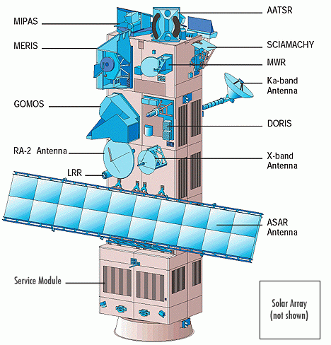
Advanced Along-Track Scanning Radiometer (AATSR)
Advanced Along-Track Scanning Radiometer (AATSR) is one of the Announcement of Opportunity (AO) instruments on board the European Space Agency (ESA) satellite ENVISAT. It is the most recent in a series of instruments designed primarily to measure Sea Surface Temperature (SST), following on from ATSR-1 and ATSR-2 on board ERS-1 and ERS-2. AATSR data have a resolution of 1 km at nadir, and are derived from measurements of reflected and emitted radiation taken at the following wavelengths: 0.55 µm, 0.66 µm, 0.87 µm, 1.6 µm, 3.7 µm, 11 µm and 12 µm. Special features of the AATSR instrument include its use of a conical scan to give a dual-view of the Earth's surface, on-board calibration targets and use of mechanical coolers to maintain the thermal environment necessary for optimal operation of the infrared detectors. AATSR data can be downloaded from ESA.
Mission
AATSR
Sensor
Advanced Along-Track Scanning Radiometer (AATSR)
Spacecraft
Envisat
Launch date
1st, Mar. 2002
Design life
3 years with a goal of 5 years
Orbit
Sun-synchronous polar orbit (SSO): Nominal reference orbit of mean altitude 800km, 35 days repeat cycle, 10:00am mean local solar time (MLST) descending node, 98.55°. inclination. [envisat.esa.int]
Spacecraft operations control centre
ESA
Accuracy
Sea surface temperature: <0.5K over 0.5 deg x 0.5 deg (lat/long) area with 80% cloud cover Land surface temperature: 0.1K (relative)
Swath (km)
Waveband
Spatial resolution (m)
IR ocean channels: 1km x 1km, Visible land channels: 1km x 1km
Temporal resolution
35 days repeat cycle